
Glacier Valley’s Heliport and Explosives Depot moves closer to construction
By Chase Berenson
TNews Staffwriter
At the March 9th meeting of Anchorage’s Planning and Zoning Commission, the Commissioners unanimously passed PZC Case 2026-0042 to change the definition of the Girdwood Airport (GA) zoning district in a way which would allow a heliport and explosives depot to be built in the southeastern reaches of Glacier Valley. There is a lot to unpack in that sentence, but this work ensures the safety of Alaskans will improve while driving the Seward Highway in winter.
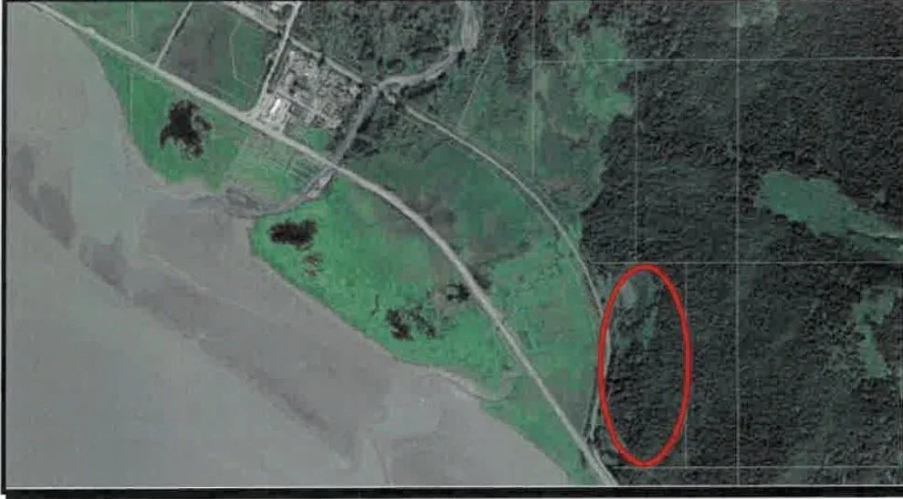
Location of the proposed heliport and explosives depot circled in red; for context, Old Girdwood is visible in the center left of the image. (Photo Credit: DOT’s Application for Zoning Map Amendment submitted to the Municipal Planning and Zoning Commission)
According to Alaska Statute (AS) 19.05.030 the Alaska Department of Transportation & Public Facilities (DOT) has nine legally enshrined duties, and number seven on the list is to “develop and implement an avalanche control plan to protect persons who use public highways.” To perform that duty, the DOT created the Snow Avalanche Program to improve motorist safety by reducing avalanche hazards while also minimizing avalanche-related traffic delays and road closures. The Snow Avalanche Program has existed since the 1970s and their tools and methods of work have changed dramatically over the decades.
Avalanche Mitigation
The DOT utilizes a range of methods to mitigate avalanche risks, and the preferred mitigation methods are passive and permanent. For example, in the 1990s the Bird Flats area north of Girdwood (approximately miles 97-99 of the Seward Highway) was the most dangerous section of road in the United States for avalanche danger. To mitigate this risk, the road and Alaska Railroad tracks were realigned and moved out towards the waters of Turnagain Arm and away from the mountains. Additionally, the elevated bike path on the north side of the Highway was built to serve as an avalanche dam which keeps avalanche debris off the Seward Highway. This is an example of passive mitigation, because during a winter avalanche event DOT crews don’t actively perform any actions to realize the benefits of mitigation. This is also considered a permanent mitigation measure because the road alignment cannot be easily undone in the future.
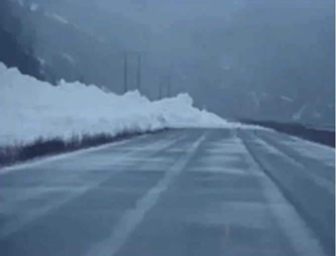
Avalanche debris blocks the Seward Highway at approximately milepost 98 in Bird Flats from an avalanche in the 1990s. (Photo Credit: Screenshot of a presentation given by Timothy Glassett, DOT’s Avalanche and Artillery Program Manager, to Imagine Girdwood in January 2024)
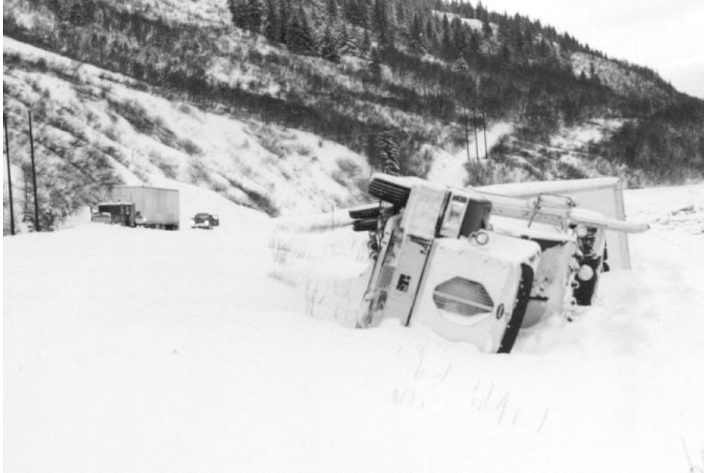
A truck knocked over by an avalanche’s air blast near milepost 98 of the Seward Highway in Bird Flats on February 20th, 1995. (Photo Credit: DOT’s Snow Avalanche Program website (https://dot.alaska.gov/stwdmno/avalanche.shtml)
The DOT also uses several avalanche mitigation measures that are not permanent nor passive, and one of the most well-known mitigation measures is the use of Howitzer military artillery. The DOT’s primary artillery tool is the M101A1 Howitzer which fires 105-millimeter (mm) shells. The M101A1 has a storied past, and defending Alaskan drivers on the Seward Highway these guns defended Allied forces in both the European and Pacific theaters of World War II. The DOT utilizes Howitzers to shoot shells at dangerous avalanche terrain when the conditions for an avalanche are high, with the goal of triggering a controlled avalanche. The DOT can choose to trigger the controlled avalanche at a time when the road is empty, and the DOT can do it when the avalanche is relatively small rather than allowing snow conditions to grow into a larger avalanche.
However, there are downsides to the Howitzers. One of the main drawbacks is the cost of their operation. The DOT leases their Howitzers from the United States Army, and part of the lease agreement requires the DOT to maintain the Howitzers to Army standards. The DOT pays military contractors to perform that maintenance. Until recently those contractors made a short drive from Anchorage’s Joint Base Elmendorf-Richardson (JBER), however the JBER support has been pulled as the Army reduces support for civilian use of artillery; without that option, the DOT now pays significantly higher costs to hire contractors to travel to the Seward Highway from the Lower 48. The even more dramatic increase in costs is for ammunition. Each individual 105-mm shell fired by a Howitzer previously cost the DOT approximately $100 to purchase. After Russia’s invasion of Ukraine in February 2022 triggered a European war that is still ongoing, the United States supported Ukraine militarily by providing 105 mm high explosive semi-fixed ammunition. This is the same type of shell used by the DOT, and the supply of these shells in the United States has dropped precipitously. The good news is that these shells are still actively in use with the Army (both US and Ukraine) so the rounds are still being produced, however the rounds being made today are significantly more expensive than the historical rounds from the 1960s and 1970s that the DOT purchased in previous years. The historical rounds have gone across the Atlantic to Ukraine, leading to a five-fold price increase for the modern rounds. In approximately one to three years the DOT will need to purchase more ammunition, and at that point it is forecast that they will cost approximately $500 per shell.
Another drawback to using the Howitzers beyond cost is the time of road closure. When the DOT has decided to utilize the Howitzers, they move their guns and crews into position and then shut down the Seward Highway. This is a safety precaution because even though these are “controlled avalanches,” it is truly hard for humans to control Mother Nature. Once the Highway is closed the DOT must sweep the road, which means driving the road to ensure that there are no drivers who are in the closed section. It takes the DOT approximately 10-15 minutes to close and sweep the road, which means drivers have been sitting on the Highway for a quarter-hour before the shooting has even started. In an average mitigation event the DOT shoots 12-16 shells, and each shell requires approximately three to four minutes to safely load and shoot.
This math means that in an average mitigation event on the Seward Highway, the road would be closed for approximately 79 minutes and the DOT would spend $1,600 on shells alone; by 2029 that cost would increase to $8,000 in shells.
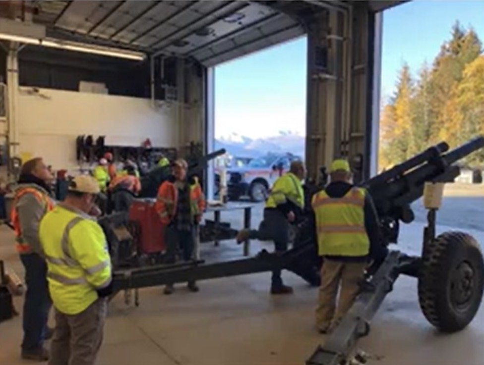
DOT crews undergo Howitzer training before the winter season. (Photo Credit: Screenshot of a presentation given by Timothy Glassett, DOT’s Avalanche and Artillery Program Manager, to Imagine Girdwood in January 2024.)
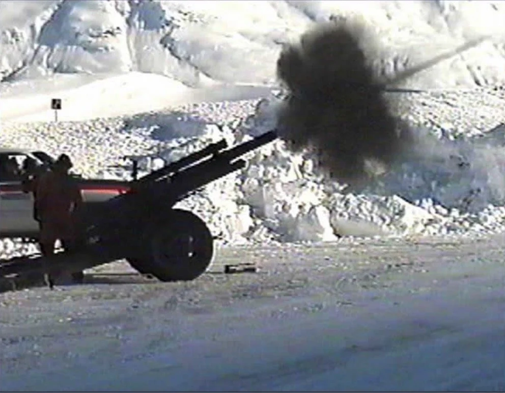
The DOT fires a Howitzer in an undated photo. (Photo Credit: DOT’s Snow Avalanche Program website (https://dot.alaska.gov/stwdmno/avalanche.shtml)
With the climbing costs and a goal of minimizing avalanche-related traffic delays and road closures, the DOT is looking at other avalanche mitigation methods.
Understanding Avalanche Risk
The federal government mandates that every state create a Highway Safety Improvement Program (HSIP) that is tailored to the unique needs of the state. The HSIP requires a data-focused analysis of road needs with a goal of significantly reducing traffic fatalities and serious injuries on roads. A couple years ago the DOT performed an analysis of Alaska roads, and as part of this process the DOT created the Statewide Report HSIP Avalanche Hazard Index and Mitigation Options Assessment. Like the long and unwieldy title, this report fills a large three-ring binder with highly technical information.
The DOT analyzed mountainous roads throughout the state with a goal of assigning them a rating from the Avalanche Hazard Index (AHI), a road-specific avalanche risk equation. The AHI was developed in 1974 to analyze the avalanche risks of highways in the Canadian province of British Columbia, and its usage has since spread across Canada, the United States, and New Zealand. The AHI was created by British Columbia’s Avalanche Task Force because it provided a wholly quantitative tool for safety planning and it removes local politics from the safety decision making. In Girdwood people may be more familiar with avalanche forecasting for backcountry recreation, which considers slope, aspect, elevation, weather, and other elements for predicting the odds of experiencing an avalanche; outside of the forecast itself, backcountry recreators should also consider “the human element” which includes how they or others may be impacted by an avalanche. The AHI also includes a human element, but using a different approach and terminology.
The AHI uses a complex equation to determine avalanche risk to a road. It includes elements such as the number of avalanche paths and the type of avalanches, but it includes two other factors not seen in backcountry avalanche forecasting: the probability that an avalanche will encounter a moving car on the road, and the probability that (if an avalanche were to have occurred and closed the road) a second avalanche will encounter a stopped car on the road. Beyond covering technical elements like slope angle and aspect, the AHI uses traffic volumes as a key driver for calculating roadway hazards.

The equation for calculating the Avalanche Hazard Index. (Photo Credit: “The Avalanche-Hazard Index” published in the 1989 edition of Annals of Glaciology)
By analyzing Alaska’s highways, the DOT was able to calculate the highest risk areas using the AHI. The five highest risk areas in the state are:

Though other highways may have more dramatic avalanche paths, the Seward Highway experiences approximately 6,000 vehicles per day between Girdwood and Anchorage. The Highway’s high traffic volume causes the Seward Highway to be ranked at the top of the list, with an AHI score that is 55% higher than the second-highest risk location. Furthermore, the Seward Highway is Alaska’s only roadway with an AHI score higher than 150, which is classified as Very High and requires mitigation measures such as, “full-time forecasting and mitigation with explosives, permanent structures, etc.”
The Future of Avalanche Mitigation
As Alaska phases out the use of military artillery for avalanche mitigation, the DOT is looking to more modern civilian avalanche mitigation tools. There are several companies manufacturing remote avalanche control systems, or RACS. These RACS typically involve the construction of permanent towers in the mountains over known avalanche chutes and risk areas from which explosives can be dropped directly from the tower. The explosives used by RACS are not military artillery but are civilian explosive charges. RACS are used throughout the world but are relatively new to Alaska; the Alaska Railroad uses a RACS, but that is the only one in the state.
The DOT is interested in RACS because they solve many of the drawbacks of the Howitzers, especially cost and time. Since neither the explosives nor the firing devices are military, costs are significantly cheaper on the civilian market. RACS also dramatically reduce road closure times for mitigation. British Columbia’s Ministry of Transportation and Transit has published reports about the Trans-Canada Highway’s route through Three Valley Gap where RACS have been installed. In the ten years prior to the installation of RACS in Three Valley Gap, the Trans-Canada Highway averaged 46.5 hours of avalanche-related closures per year spread across 12 closure periods; in the nine years after the installation of RACS, the average time for mitigation control was down to 10-30 minutes. Furthermore, the RACS use mobile apps for operation. Rather than training teams to use military artillery, DOT workers can trigger the explosives by pushing a button on their phone.
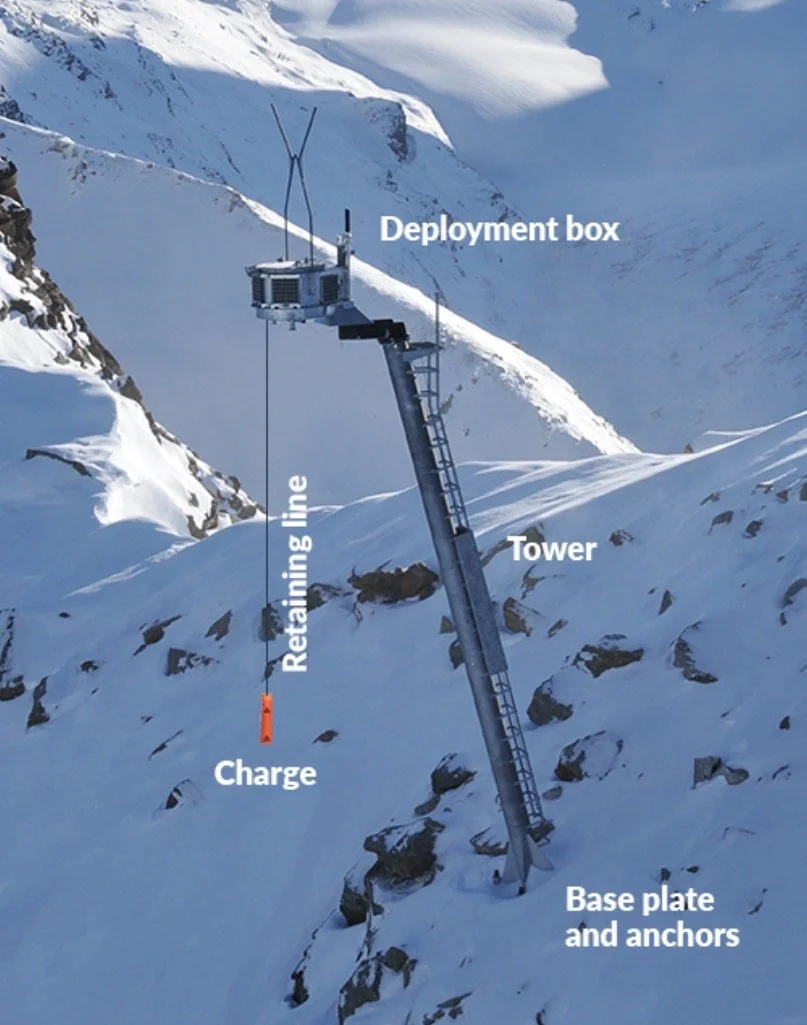
The Wyssen LS12-5 avalanche tower, part of a Wyssen RACS. (Note: Wyssen is one of many RACS manufacturers, and this image is shown as an example; it is unclear whether the DOT has decided on a specific RACS manufacturer or product yet.). Photo Credit: Wyssen’s website, with text already added before publication on the website below: (https://www.wyssenavalanche.com/en/preventive-avalanche-release/wyssen-avalanche-tower-ls12-5-and-ls24-5/)
The introduction of RACS would necessitate more than simply building avalanche towers in the mountains. The DOT would use helicopters to move explosives to the RACS and prepare them for avalanche mitigation work, which means the DOT would not only need a site to launch helicopters but also needs a site with explosives storage magazines.
Virgin Creek Material Site
The Virgin Creek Material Site, an abandoned gravel quarry, is a nearly forgotten spot in the southeastern portion of Glacier Valley. The land is owned by the Alaska Department of Natural Resources (DNR), though in the 1960s the DNR entered an Interagency Land Management Transfer (ILMT) with the DOT. This ILMT allows the DOT to utilize the land for highway use, and the DOT has determined that using the land for RACS support not only meets the highway use threshold but also “is in the best interest of the State of Alaska to be used for public safety along the Highway and Railroad corridors within Southcentral Alaska” according to documentation presented to Girdwood’s Land Use Committee on January 12th, 2026.
The Virgin Creek Material Site is accessed from the Seward Highway via an access road that appears to be long abandoned. The driveway is approximately one-lane wide and overgrownwith vegetation. The driveway is blocked by what appears to be a soil berm a few feet tall to prevent drivers from attempting to enter the access road, and then beyond the berm is an old gate with an Alaska Railroad “No Trespassing” sign that has been used for target practice.
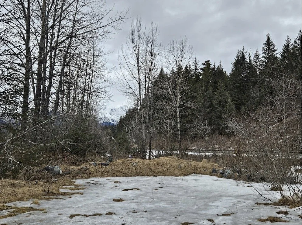
The view of the driveway entrance to the Virgin Creek Material Site from the Seward Highway, illustrating the overgrown berm, as seen on April 18th, 2026.
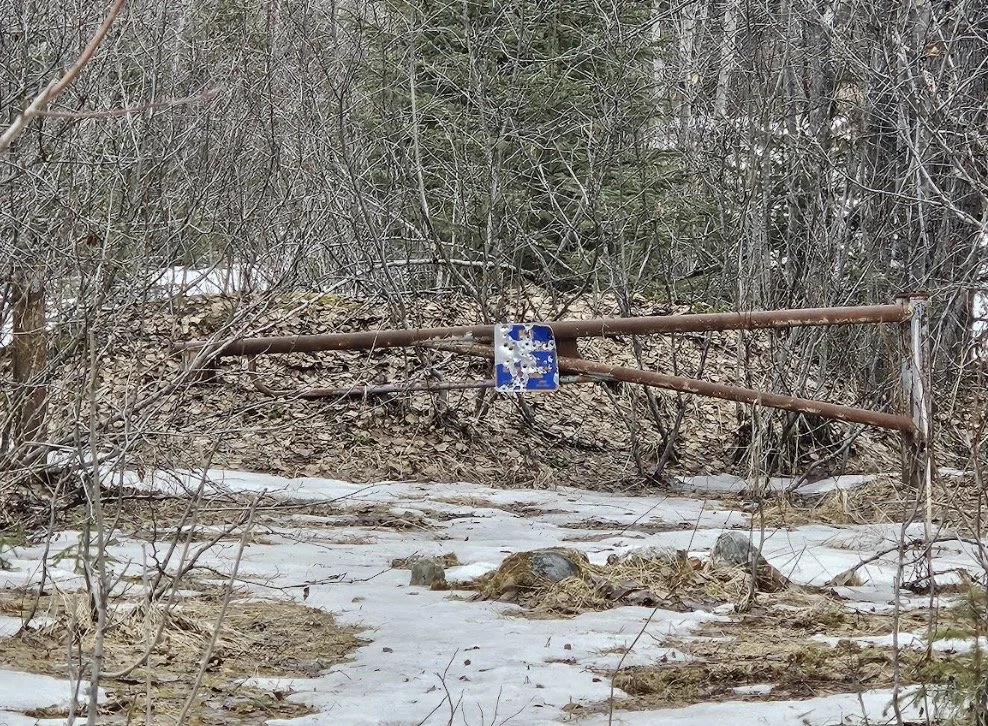
The gate blocking the driveway to the Virgin Creek Material Site viewed from outside the berm with the Alaska Railroad’s “No Trespassing sign” featuring firearm damage, as seen on April 18th, 2026.
The DOT would need to improve the access road (including an uncontrolled crossing over the Alaska Railroad tracks) and flatten the ground surface of the old gravel pit before the agency could build the heliport and the explosive storage magazines that would hold the 60,000 pounds of explosives. There are specific safety thresholds and distances required to be considered for explosives storage, which the DOT has already factored into the plans. DOT has studied other sites and landholdings along the route of the Seward Highway, and it indicates that there is no other location that can adequately meet the DOT’s needs.
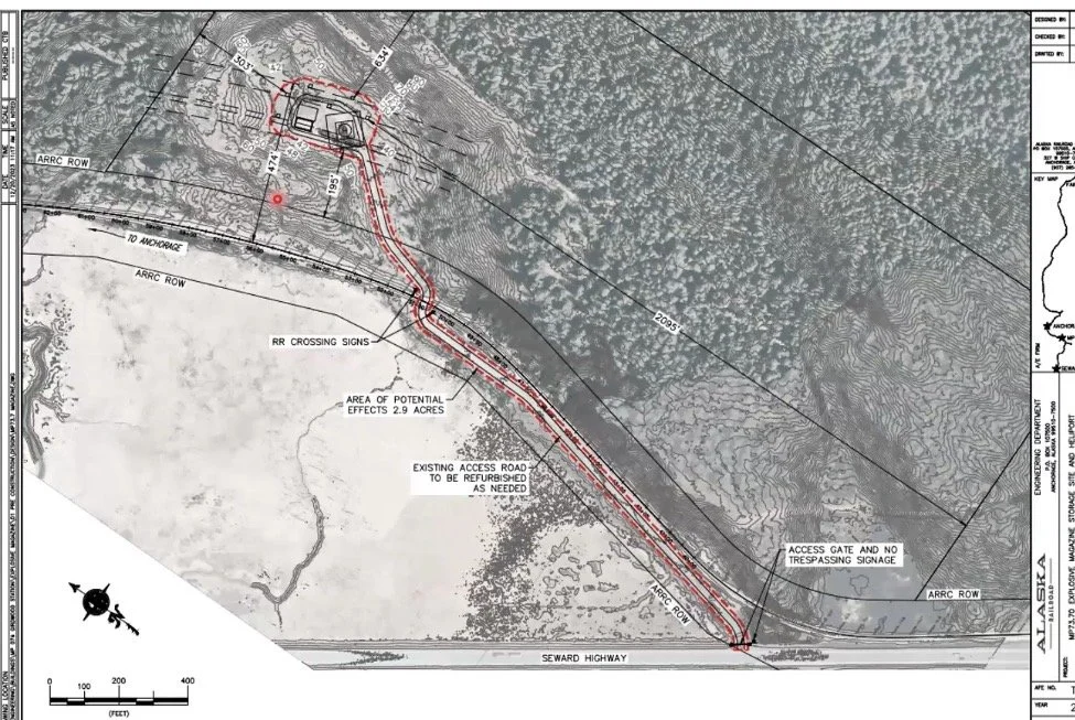
The engineering plan for the Virgin Creek Material Site, including the access road. (Note: the plan refers to milepost 73.70; in this context that is the railroad track milepost, not the Seward Highway milepost.) (Photo Source: Screenshot of a presentation given by Timothy Glassett, DOT’s Avalanche and Artillery Program Manager, to Imagine Girdwood in January 2024.)
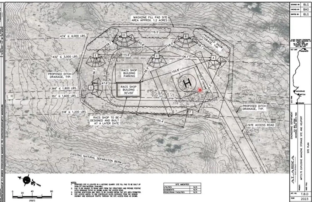
The engineering plan for the Virgin Creek Material Site, detailed view of the heliport and explosive storage magazines. (Note: the plan refers to milepost 73.70; in this context that is the railroad track milepost, not the Seward Highway milepost.) (Photo Credit: Screenshot of a presentation given by Timothy Glassett (DOT’s Avalanche and Artillery Program Manager) to Imagine Girdwood in January 2024.)
The site is in an undeveloped part of Glacier Valley, over three-quarters of a mile from the nearest residences in Old Girdwood. The land surrounding the site (and the site itself) are in the GDR (Girdwood Development Reserve) zoning district so they are not zoned for residential use, and there is no future expectation of residential construction closer to the site. The only future development near that area of the Valley could be the potential road access to provide secondary access into Girdwood. This explosives storage site is near the Alaska Railroad tracks which requires it to be built to specifically protect transportation infrastructure; because of these requirements, it wouldn’t hinder any future road development through the area.
Once the site is constructed, the DOT would use it to transport explosives via helicopter to RACS devices that would be built both north and south of Girdwood along the Seward Highway. The DOT has already received the required Federal Aviation Administration (FAA) designation for a heliport, and the site is allowed to have up to 30 flights per year. The DOT predicts that there will be a couple fall flights to set up the tower sites and spring flights to decommission them after the season, but most of the heliport usage will be during the winter. It will be easier for the DOT to transport their explosives to the southern RACS sites, because they will be able to take off fully loaded directly from the heliport. However, aviation regulations prohibit the transport of helicopter slingloads over populated areas and the DOT does not want to fly explosives over residences, so they won’t be able to fly over Girdwood to reach the RACS sites north of the community. To access sites to the north, the DOT will have to transport materials and explosives via truck to a location north of Girdwood where the helicopter will meet the truck and the load will be transferred to the helicopter.
The plans are all in place and the DOT is ready to move forward, however there is a problem: heliports and explosive storage depots don’t fit well into the Municipality’s existing zoning structure.
An Avalanche of Paperwork
The DOT has been working on this plan for years. In 2023 the Muni had recommended that the DOT apply for a special use permit for operation of an electric utility substation since that was the nearest approximation to this land use type, however, since this isn’t a utility substation the Muni’s guidance shifted in 2024.
Though Girdwood is in the Municipality of Anchorage, the community has zoning requirements that sometimes differ from other Anchorage communities to better meet Girdwood’s specific needs. One of the distinct zoning districts in Girdwood is known as GA, which stands for Girdwood Airport. If this site were zoned as GA, that would clear the way for these unique aviation operations. However, zoning changes are rarely easy, and this one featured some distinctive hurdles.
First, the GA designation would allow the aviation operations but not the explosives storage; the site would need to be overlayed as an industrial site to store the explosives. Secondly, the GA district was defined in the Muni’s Title 21 code toinclude the specific geographic location of the Girdwood Airport. After years of working towards resolution, successesare starting to pile up for the DOT
The DOT worked with Imagine Girdwood during the creation of the Girdwood Comprehensive Plan, which included planning for the parcel to be industrial and to be an aviation site. Then on February 9th, 2026, the PZC agreed to perform minor updates to Title 21 to align it with the Girdwood Comprehensive Plan, including the industrial overlay. These updates also included revising the GA zoning definition so that GA is no longer restricted to a geographic location; instead, the GA zoning district, “is appropriate where the comprehensive plan designates it as an implementation zone,” which includes both the Girdwood Airport and DOT’s proposed heliport. Additionally, PZC action cleaned up some repetition text in Title 21 and refined the definition of “Government Services” to a definition that would encompass the proposed use of the heliport and explosives depot.
Once the regulations were modified to allow the use, at the PZC’s meeting on March 9th, 2026, the Commission voted to rezone the parcel from GDR to GA to allow the project to move forward. These positive votes trigger the actions to move to the Municipal Assembly along with the formal notice that the Commission recommends that the Assembly approve the actions.
These issues were introduced at the April 14th Muni Assembly meeting as AO 2026-51 (which will update Title 21 to create the required zoning for the project to move forward) and AO 2026-52 (which will rezone the parcel into the newly approved zoning district definitions). Once items have been introduced at an Assembly meeting, they come up for public comment and debate at a future meeting.
Next Steps
The Muni Assembly will hear both ordinances AO 2026-51 and AO 2026-52 at a future meeting. So far neither ordinance has received any objections or negative comments, though they have received supporting comments from the DOT and Ted Stevens Anchorage International Airport as well as a resolution of support from the Girdwood Board of Supervisors.
Assuming the ordinances pass, it is difficult to state what exactly the DOT’s next steps will be. Despite multiple contacts, the DOT’s Communications Staff did not grant permission to the Snow Avalanche Program staff to participate in the creation of this article. This article was entirely generated by researching publicly accessible documents and watching archive videos of past public meetings, which provide extensive historical information but make it difficult to predict the future.
Presumably if the ordinances pass, DOT will begin moving forward with construction on the site and the installation of RACS towers throughout the Seward Highway corridor with an aim to integrate the RACS before the next round of Howitzer artillery will need to be purchased in the next one-to-three years. One thing that is certain is the DOT will continue working to improve motorist safety by reducing avalanche hazards while also minimizing avalanche-related traffic delays and road closures.