
MOA responds to TNews Inquiry on current ‘Holtan Hills’ construction
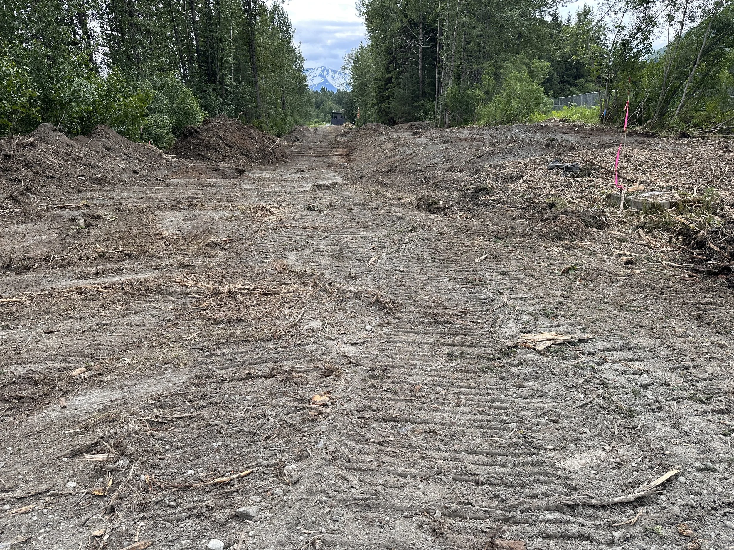
The utility easement for the Holtan Hills housing development from July 8. (Photo by Soren Wuerth)
By Soren Wuerth
TNews Editor
The Municipality of Anchorage responded late Friday to a slew of questions by Turnagain News regarding the so-called "Holtan Hills" subdivision development currently underway off Hightower Rd. near the school.
The project is a joint effort by Anchorage developer Connie Yoshimura and the city's Heritage Land Bank, which manages most of the land in Girdwood's valley. "Holtan Hills", so named by a small group acting without community consent, has little local support. It was nevertheless approved by the Anchorage Assembly in January, 2024.
The HLB recently signed an agreement for $2 million with Anchorage-based GMC Contracting for "off-site" development of a road and sewer connection, impacting approximately 2.5 acres, according to the city and Yoshimura. The project is expected to last into August when children return to school.
GMC began tearing a swath to the toe of the 60-plus acre housing development on July 7.
Responses, provided through an email from the muni's public affairs office, are in italics.
Has a traffic study been conducted to determine existing traffic patterns, densities, and vehicle traffic amount on Hightower Road?
During the early planning stages of this project, both the [Municipality of Anchorage] Planning Department and Traffic Engineering Department reviewed the potential density within the development and concurred that the road improvements would be built to local residential street standards which would not require a (traffic study) traffic impact analysis prior to construction.
Where can we view the traffic plan?
See previous response regarding the traffic study. A traffic control plan will be submitted and available for public review prior to disturbance and reconstruction of affectioned portions of Hightower Rd.
How will the impacts of heavy operating equipment be mitigated?
Heavy equipment will be trailered to the site in accordance with the [Alaska Department of Transportation] and [Municipality of Anchorage] Right-of-Way load weight limits. Excavators and other similar heavy equipment will not operate on fully improved/paved roads or sidewalks that aren’t planned for demolition/upgrade.
Is there an opportunity for local hire regarding a flagging company?
The selected contractor, GMC Contracting, is an Alaska-owned and operated construction company that employs local skilled labor. They will be handling signage and any necessary flagging of the construction site.
What plan is in place for cleaning roads during and after construction and who is responsible?
GMC Contracting will sweep roads as needed in accordance with the [Stormwater Pollution Prevention Plan]. This will primarily occur during haul off and haul in when dirt tracking is at its highest. It will also be done as needed outside of the hauling windows.
Has a survey been conducted to determine the boundaries of school district property to include the Athabascan Trail system and will it be impacted?
Yes, a survey has been completed of the school property boundaries and affected trails. The new road crosses the Athabascan Trail which will remain in the same location. The trail will be temporarily closed during active construction for the safety of trail users and construction crew.
How will the developer mitigate impacts to two trail systems: the Middle Iditarod Trail and the Anchorage School District's Athabascan Trail?
During active construction, access to these trails will be temporarily closed at the intersections of the project area. Upon completion of the project, sections of the Middle Iditarod Trail will be realigned along the paved pathway parallel to the new road. It will intersect and provide a connection to the Athabascan Trail which then connects back into the soft-surface sections of the Middle Iditarod Trail.
Will the developer/contractor work during school hours?
Yes. Road construction will continue through late September.
Is there any buffer planned between the school's property and construction to mitigate impacts and offset safety concerns?
Construction will remain on the south/east side of the existing fence line of the school. A buffer of mature vegetation will remain between the fence line and road. The construction schedule and traffic control plan will be shared with ASD staff.
What plans are in place for the safety of pedestrians, bicyclists, vehicle traffic, and school children during construction?
A traffic control plan will be further developed once the construction schedule gets closer to bike path and road demolition so utilities may be connected to mains along Hightower Rd. Temporary chain-link fencing is currently onsite to delineate the active construction zone.
Has the developer had discussion with ASD personnel to discuss impacts, generally, to its properties and what conclusions and/or commitments were made?
The construction schedule and traffic control plan will be shared with [Anchorage School District] staff to minimize disruption of academic programs and ensure the safety of students.
What protections and environmental mitigation are planned to reduce impacts to the watershed containing the creek to protect other properties from "downstream" impacts?
A Stormwater Pollution Prevention Plan (SWPPP) and Notice of Intent (NOI) are in place to actively mitigate potential negative impacts from construction activities.
Community members have raised concerns about heavy equipment traffic (excavators, bulldozers, gravel trucks, etc.) on the road to the school and near its playground and outdoor classrooms. What is HLB's response to these concerns?
As previously stated, all construction activity will be south/east of the school’s existing fence line. The construction schedule and traffic control plan will be shared with ASD staff to minimize disruption of academic programs and ensure the safety of students.
This map shows the project ending at the utility box. Is this the extent of "off-site" construction?
The utility box is an AWWU Pressure Reducing Valve (PRV) and is the terminus for this phase of work.
How wide can we expect the road to be? Will it be paved?
The road section will be paved to 27-foot-wide with curb, gutter and an 8-foot-wide paved pathway attached to the curb on the school side.
Is there a public notice requirement beyond a phone number?
No. However, the permit and supporting information are available for review upon request.
Was an Environmental Assessment or Categorical Exclusion conducted and where are the supporting documents?
An environmental assessment was not necessary for a project of this size. However, HLB has completed a wetlands delineation and obtained a Preliminary Jurisdictional Determination from the US Army Corps of Engineers. Any development within the delineated wetlands will be subject to approval from the US Army Corps of Engineers or Municipality of Anchorage depending upon jurisdiction.
Is there a Fish and Wildlife Service and/or ADFG permit and why isn't it in the SWPPP?
A permit from [the Alaska Department of Fish and Game] is not required for this project. The new road improvements do not cross any streams, nor do they impact the stream setbacks to Glacier Creek.
What protections are in place for Glacier Creek, an anadromous fish stream? What is the easement restriction for Glacier Creek?
A SWPPP with active monitoring is in place. Additionally, a vegetated buffer and silt fencing will remain between the construction activities and the creek. Glacier Creek has an existing platted 25-foot Creek Maintenance Easement on the west side. The improvements do not encroach into this easement.
Why are contractors only using a silt fence and no straw wattles or other fiber rolls?
The type of best management practices used on site can vary depending upon the situation. For this project, silt fence was determined to be the best option because it restricts sediment movement and also creates a clear physical barrier on project limits. Straw wattles and fiber rolls can be driven over and are useful in other applications, however silt fence creates a more significant barrier and does a better job of prohibiting sediment migration. The site plan within the SWPPP is an active document and will be updated and revised as site conditions require.
Where will Porta-Potties be placed (there is no indication on the SWPPP)?
Likely in the staging area. The site plan within the SWPPP will be updated once those are delivered to the site.
Where is vehicle fueling and equipment storage?
This is anticipated to remain within the existing gravel parking area.
Are there any water rivulets or drainages across alignment?
No streams or ephemeral channels exist within the alignment of these improvements. An existing culvert will be replaced/upgraded to facilitate drainage of a low-lying area.
Where is the staging area to be located?
Within the existing gravel parking area.
Any there any eagle nests in the area? Who conducted a bird nesting survey?
No. GMC’s Superintendent completed a site walkthrough prior to clearing with no nests identified.
Has Athabaskan Trail (SHPO) been subject to architectural survey?
No, the Athabaskan Trail is an interpretive trail constructed by ASD and is not identified as a historic trail requiring an archeological survey. However, if any historical or archeological artifacts are discovered as part of this project, the construction schedule will be modified so the artifacts can be properly identified, excavated, cataloged, and preserved.