
Portage Lake Tsunami Could Reach Turnagain Arm and Whittier
Forest Service Employees and Public Left Unaware of Danger, Sources Say
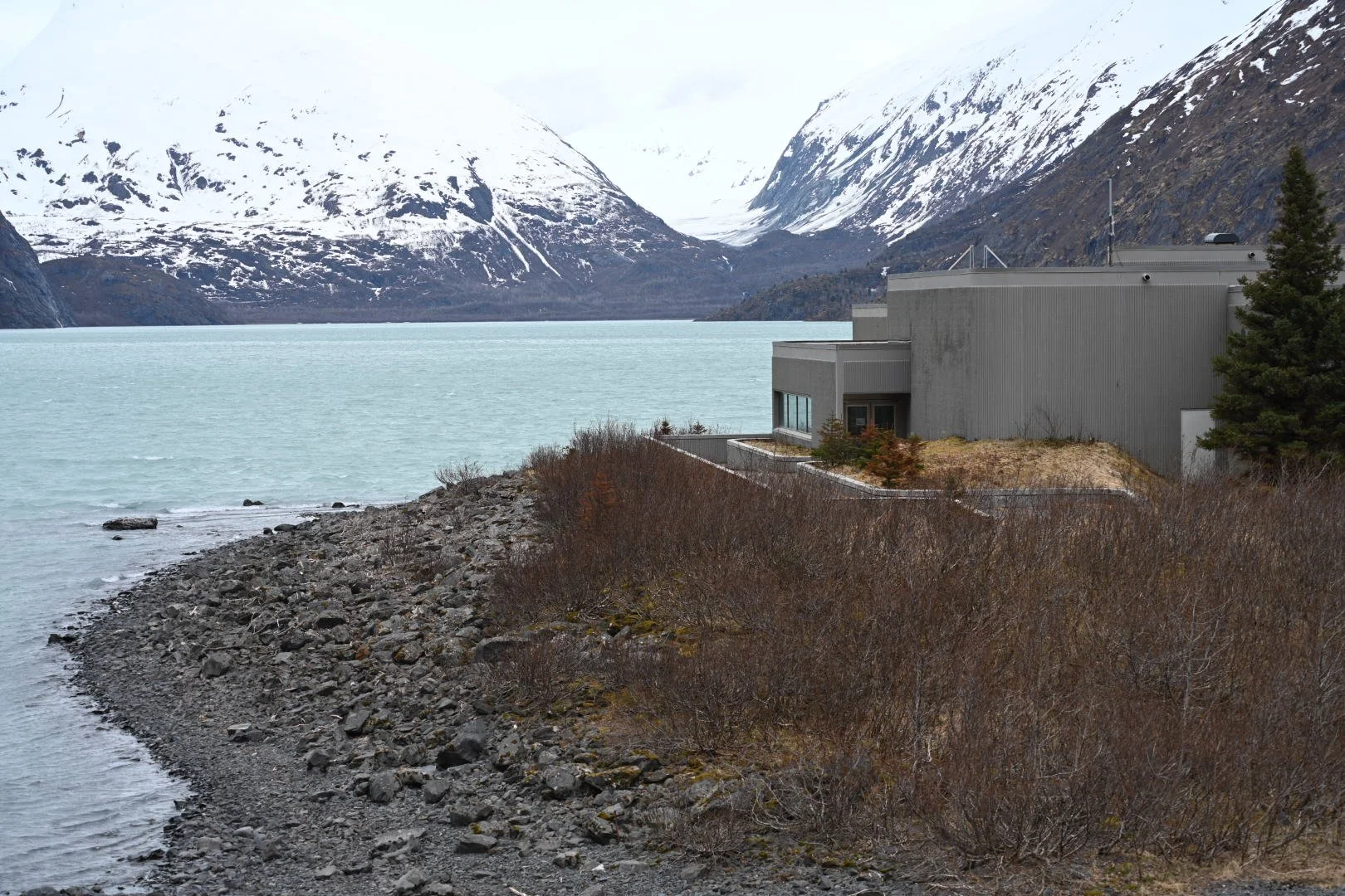
The Begich, Boggs Visitor Center opens Friday. A tsunami created by a collapsing landslide would reach the facility in two-four minutes, experts say. (Photos by Soren Wuerth)
By Soren Wuerth
TNews Editor
A hulking mountain face slowly sinking toward Portage Lake could collapse and send a massive wall of water hurtling into the Portage visitor center and down a valley six miles to Turnagain Arm, according to experts and a Forest Service emergency action plan.
Geologists fear a landslide-triggered tsunami more than 1,000 feet high could, like sloshing water in a bathtub, sweep through valleys, enter the 2.5-mile long Whittier Tunnel and even breach the 500-foot Portage pass, sending muddy water and debris into Passage Canal.
Yet, as catastrophic as it sounds—and given growing concern about landslides, sporadic news coverage and heightened awareness—few warnings have been issued about the possibility of a major disaster at a popular tourism destination that opens Friday.
"You think about some dramatic event like a tsunami on Portage Lake and it sounds pretty implausible until after it's happened. And that's kind of an instinct we, or at least a lot of people, have," said independent geologist Bretwood "Hig" Higman, who has consulted for the government on a number of landslide risk zones.
Portage's Begich, Boggs Visitor Center, a popular tourism destination that sees up to 1,000 visitors a day, sits directly in the path of a potential tsunami and 2.5 miles from the toe of Portage Glacier.
Higman estimated a catastrophic tsunami at Portage has one in 30 yearly chance of occuring and a wave that magnitude would give a person two to four minutes to evacuate. The landslide is currently moving at a rate of a meter per year.
There have already been three "dramatic" landslides at Portage, Higman said, one in 2022, another in 2024 that slipped down the glacier, and a third last September. "It went directly into the lake and I think it's big enough that if it had been moving a bit faster, it might have produced a dangerous tsunami," he said.
Similar landslides have happened in other coastal areas, including an incredible 1,500-foot wave from a landslide in Tracy Arm near Juneau last summer.
Portage, said Higman, is "flying those red flags a little more wildly," and September's event is "kind of a duh of risk factors for landslides, but I think it's a really important one."
"No explanation"
Though it has known about the tsunami threat for at least two years, the Chugach National Forest has kept its own employees and the public largely in the dark, Forest Service sources said.
Just weeks ago, an annual Forest Service meeting planned for the visitors' center at Portage was abruptly cancelled, employees said, adding they were offered no explanation.
"The Forest Service has not communicated about this at all," said an employee who spoke on condition of anonymity. "It's a bold decision and quite scary actually."
Reached by phone Wednesday, Glacier District Supervisor Chris Stewart referred questions to the Forest Service's public affairs department.
In a response to an email, Public Affairs Officer Amanda Wheelock wrote that the Forest Service is "partnering with other agencies to support community safety and preparedness".
Wheelock said her agency is evaluating the slope above the glacier and monitoring precipitation forecasts, among other things, "to determine if a temporary closure of the Begich, Boggs Visitor Center is necessary."
She said staff at the visitor center know about risks posed by the landslide, have "protocols in place" and regularly conduct evacuation drills.
At least five employees work at the visitor center over the summer. Its director, Kyle Gallaher, also referred questions to the public affairs office. Wheelock did not reply to other questions in time for publication.
Several employees spoke with Turnagain News confidentially with one saying "the chatter in the (Forest Service) community is widespread". All said they were not informed of the risk or given a copy, obtained by Turnagain News, of an eight-page emergency action plan. Though the plan is undated, it states that the agency was "aware of a potential landslide/tsunami threat in Portage Lake" since it was documented by the U.S. Geological Survey in 2024.
"The agency recognizes that if a landslide were to occur rapidly and catastrophically, it would likely have significant impacts on Forest Service infrastructure in the upper Portage Valley," the emergency action plan says.
Concerns include landslide debris crashing into a tour boat—the M/V Ptarmigan, that makes daily trips across the lake—or ice skaters, as well as "on-water (or ice) impacts" to boats and people, and "inundation along the shoreline and downstream".
"Conservative modeling scenarios suggest a wave of 20-30 feet arriving at the [visitor center] within 2-4 minutes, though the wave could be much larger or smaller," the plan states.
It also notes that "there is no clearly accessible high ground in Portage Valley. The most viable evacuation route for employees and the public involves driving out of the Valley, toward the Seward Highway."
Yet, for people camping along the Portage Glacier Rd, for tourists shuttled to parking areas and for passengers and crew on the Ptarmigan, a 144-passenger tour boat that plies the lake five times a day in the summer, little information has been conveyed about the threat, according to workers.
A bunk house that hosts up to 12 employees during the summer is a little over a quarter of a mile from the visitor center and Forest Service employees regularly pass through the valley on work-related assignments.
"As an employee and someone who likes to go camping, this information needs to go public," one source said. "It's straight up negligent that this information has not been shared with the public and I fear if something happens and people die, I don't think that Glacier Ranger District will be able to recover from that."
Another source knowledgeable about the landslide and tsunami threat called the agency's lack of transparency "colossally negligent".
Last September, the Begich, Boggs closed to the public and Portage Glacier Cruises cancelled tours after 10 inches of rain fell in four days. Stewart pulled staff from the visitor center and told KTUU at the time there was no immediate risk of tsunami, but a landslide and wave were possible. He said there were no evacuation orders and sent employees back after several days.
There have been no warnings issued on the Glacier District's website, or any other Forest Service webpage, no postings at the visitors center and no public statements by officials. The Forest Service, however, issues regular avalanche information and has a banner on its cabin reservation page alerting the public to another tsunami threat in Barry Arm.
Recently, employees say they found out by chance of an emergency evacuation plan citing dangerous conditions at Portage.
Another Forest Service source said employees have been told not to deny any permits for operations. Two employees of Portage Glacier Cruises said they knew nothing about a looming danger of landslide or possibility of a tsunami.
As of last weekend, a sign on the building said the Begich, Bogs Visitor Center is scheduled to open this Friday before Memorial Day weekend.
An "apocalyptic" worst case scenario
Four years ago, while mapping landslides for the US Geological Survey, Higman hiked out to Portage where he noticed cracking bedrock. He had been researching another moving land mass in Barry Arm. And though millions have been spent on the site, in western Prince William Sound, he said found the unstable mass of rock west of Portage Glacier far more worrisome.
In a geologic phenomenon known as "debuttressing", where a receding glacier undermines a mountain face, the flanks along the Portage Glacier are moving at a rate of a meter per year, said Higman.
As Portage Glacier recedes, undercutting and weakening a bedrock slope, different scenarios shape the extent of disaster. Under the worst case scenario, with one in 10,000 odds, a tsunami would be "pretty apocalyptic" and would "resurface the entire Portage valley", Higman said.
The most likely scenario, Higman said, could look similar to a 1958 landslide in Lituya Bay when an earthquake triggered a 30-million cubic meter rock slide that caused a tsunami reaching more than 1,700 feet.
The mass of rock creeping above Portage Lake is around 50 million cubic meters, Higman said.
That "very plausible bad case" would "take out bridges", he said, and "the visitor center might somehow survive but would probably never operate again and you would have to be very lucky for there not to be people dying in that case."
Rain, earthquake or glacial movement are all factors that could trigger a landslide into a lake, which is over 500 feet deep in some places, he noted.
Homemade sensors (pulse coherent radar) which measure movement were placed on the mountain by Higman in 2022, and again last summer under a Forest Service grant.
The number of landslides near glaciers has been increasing across Alaska as glaciers recede due to fossil fuel-driven climate change.
Last year's Tracy Arm landslide moved 64-million cubic meters of rock and created a massive tsunami that plowed across the canal near Juneau. Though Tracy Arm is a popular destination for cruise ships, there were no vessels operating near the glacier that day.
Meanwhile, measuring equipment has gauged movement of a mountain side in Barry Arm, in western Prince William Sound, to assess the threat of a landslide and in hopes of sending an alert to vessels and officials in Whittier in the event of a tsunami.
Since the subsurface topography of Portage Lake has not been mapped and information on the structure of the mountainside and glacier is scant, it is hard to say with any exact certainty what impact a landslide would have and how far a tsunami would reach, Higman said, and the matter of making risk assessments is complex.
Nevertheless, the most likely time for a big landslide to occur is August, the rainiest month. Higman, and the Forest Service's Action Plan, cite heavy rainfall elevates the risk.
Should the public know about the tsunami risk?
Though the purpose of the Emergency Action Plan does not include a public outreach prior, several employees and Higman said people should know about the threat to be able to make decisions.
"For me it boils down to giving people the option for what type of risks they are willing to expose themselves to," said one employee.
Higman agreed with this sentiment.
"I'm not one who wants to tell people they shouldn't go visit Portage," he said. "I think people should be allowed to take risks, you know, make choices. But I think that anyone who goes there should do so with full knowledge of what they are doing and I don't think that's the case right now," he said.
Last Saturday, Wayne Howard stood near a dock for Portage Glacier Cruises waiting for the return of Ptarmigan.
Coming from Texas, he had been in Alaska only three weeks, he said. The weather was unseasonably cold and rainy and he had to speak loudly above the wind.
When asked whether he was aware of the danger of a landslide or tsunami, he looked out across the steel-grey lake.
"We'd be the first to know," he said. "They would've told us. We're on the boat."
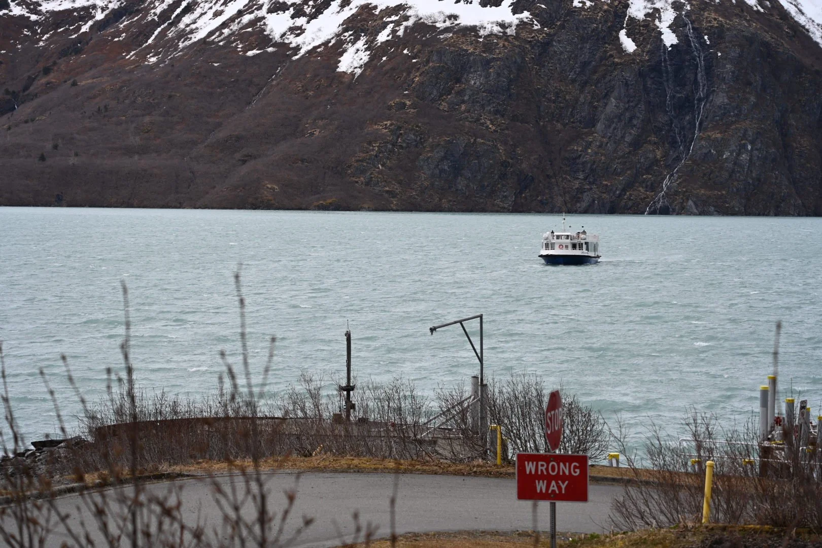
The 144-passenger M/V Ptarmigan runs five time a day. Each sightseeing trip lasts about an hour.
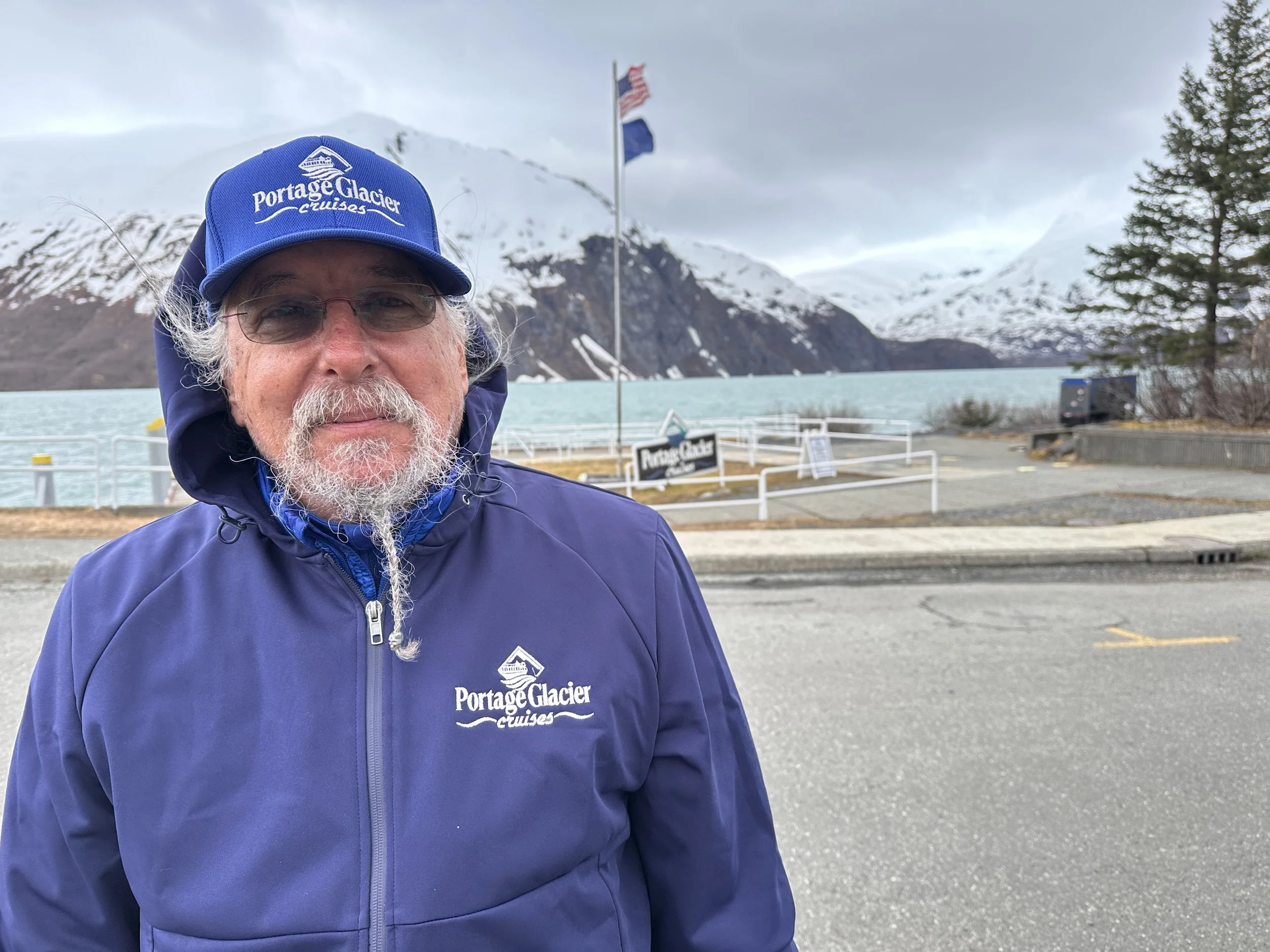
"No one's told us anything" about the threat of landslide and tsunami, said Wayne Howard, of Portage Glacier Cruises.
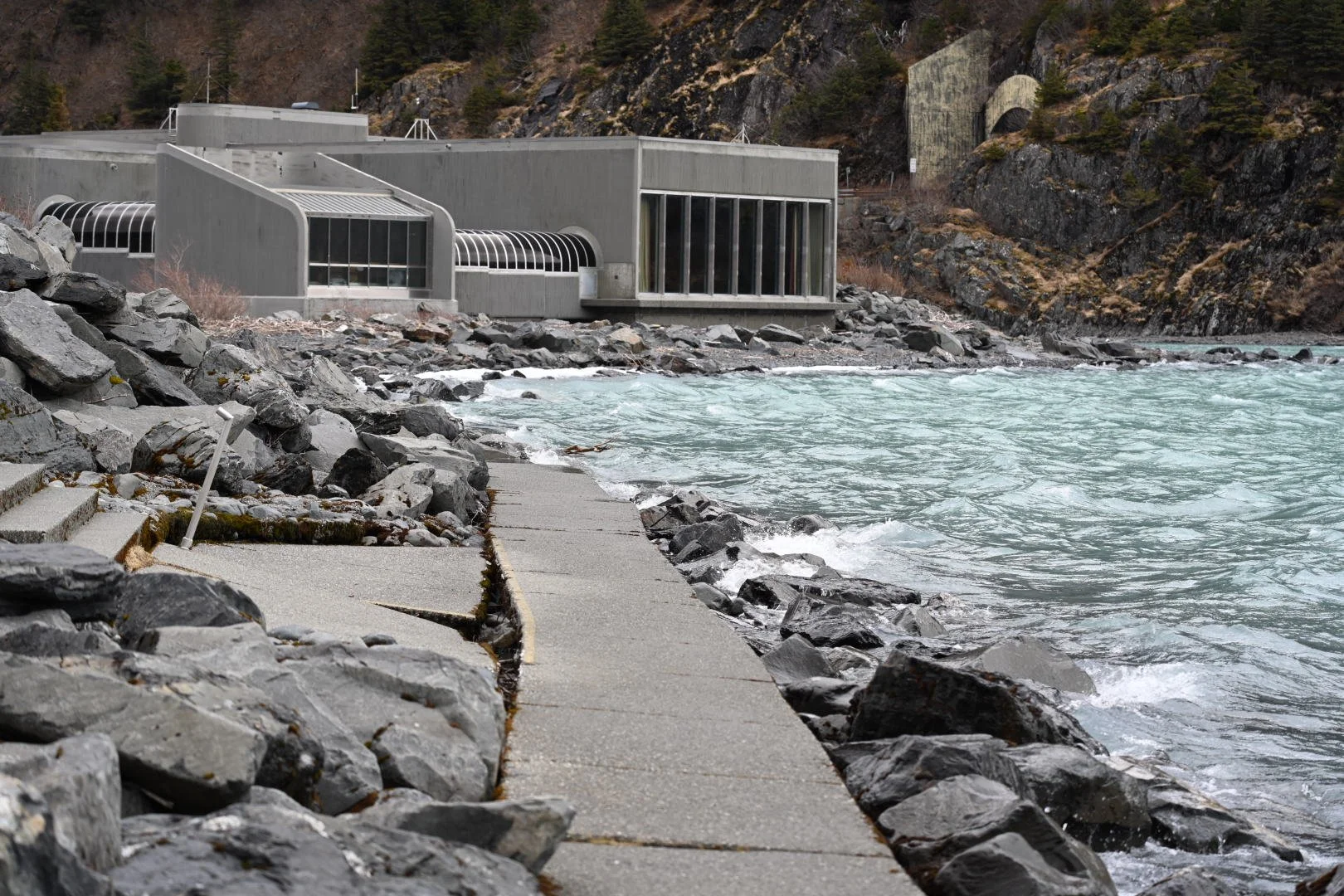
The Begich, Boggs Visitor Center, built in 1985 and staffed by at least five seasonal Forest Service employees, lies in the pathway of a potential tsunami, according to geologists.